Mont Ventoux from Bédoin: Guide to Cycling's Most Feared Ascent
Mont Ventoux from Bédoin: Guide to Cycling's Most Feared Ascent
The mythical 21.5-kilometre climb with 1,600 metres elevation gain that has shaped cycling history and forged legends since 1951
Rising 1,912 metres above the Provençal plains, Mont Ventoux stands as French cycling's most mythical ascent. The "Giant of Provence" towers with its lunar summit 40 kilometres from the Rhône Valley, visible from across the entire region. For cyclists, three routes lead to the weather station summit: Bédoin, Malaucène, and Sault. But only the ascent from Bédoin forges genuine legends.
The numbers speak volumes: 21.5 kilometres for 1,600 metres of elevation gain, averaging 7.5% gradient throughout. The steepest forest sections reach 15% in places, before total exposure to mistral winds that can blow at 100 km/h at the summit—occasionally forcing road closures.
At Baroudeur Cycling, founded by Jérôme Cousin (former World Tour professional who raced multiple Tours de France), we guide cyclists of all levels up this legendary climb. Experience the Giant of Provence through our carefully crafted cycling holidays in France designed to help you conquer this iconic ascent.
The Tour de France's Reference Climb
The Professionals' Mythical Route
Since 1951, the Tour de France has regularly climbed Mont Ventoux via Bédoin, establishing this route as cycling's ultimate reference ascent. This climb has shaped modern cycling history through drama, triumph, and tragedy that elevated Mont Ventoux beyond mere geography into legend.
In 1967, British cyclist Tom Simpson collapsed less than one kilometre from the summit, victim of extreme heat, exhaustion, and amphetamines. His death shocked the cycling world and his memorial near the summit remains a pilgrimage site. Three years later, in 1970, Eddy Merckx finished so utterly exhausted after his stage win that he received oxygen treatment—the five-time Tour winner later described Mont Ventoux as the hardest climb he'd ever faced.
Mythical and merciless, Mont Ventoux grants victory only to the strongest riders. Over the last decade, only four riders have raised their arms at the summit in Tour de France stage wins. In 2013, Chris Froome delivered an imperial performance, dropping his rivals in the final kilometres before racing toward his first yellow jersey on the Tour—a statement of dominance on cycling's most feared climb.
Three years later, in 2016, the weather unleashed its fury: violent winds forced organizers to shorten the stage to Chalet Reynard at 15 kilometres. That day, Thomas De Gendt seized the opportunity to win, whilst Froome, victim of a crash with a television motorcycle, finished the stage on foot in his cycling shoes—an image etched permanently in cycling legend.
We had to wait until 2021 to witness another show of force: Wout van Aert, riding solo, tamed the double ascent via Sault then Bédoin, leaving his pursuers far behind in a display of raw power. Then, in 2025, Ventoux found a French hero again. Valentin Paret-Peintre, 24 years old, became only the fifth Frenchman to triumph at the summit, ending 23 years of national drought—an exploit carved in rock and in fans' collective memory.
A Unique Testing Ground
Route Overview from Bédoin
The Route du Mont Ventoux starts directly from Bédoin's village centre, a charming Provençal settlement of 3,000 inhabitants surrounded by vineyards and orchards. Navigation proves impossible to complicate: only one road winds toward the summit, eliminating route-finding concerns.
The first three kilometres cross through vineyards and fruit orchards to the hamlet of Sainte-Colombe. The gradient remains moderate here—high cadence recommended whilst legs remain fresh. The trap snaps shut at the Saint-Estève bend where the mountain reveals its true intentions with gradient immediately increasing.
For a strategic stop before the ascent, Pista Café in Bédoin village provides an essential halt for cyclists, offering quality coffee and an ideal starting point at the foot of the giant. This cyclist-friendly establishment understands perfectly what awaits riders on the slopes above.
Anatomy of a Formidable Ascent
The Airless Forest Section (Kilometres 5-15)
Forest entry at kilometre 5 marks the beginning of what many describe as psychological calvary. Ten kilometres of total enclosure between dense trees, without views, without visual distraction to occupy the mind. Air stagnates oppressively even when mistral wind howls at the summit far above.
Switchbacks chain together relentlessly with 16-17% gradient passages at corner exits where momentum dies completely. The only viable strategy: small chainring engaged permanently, constant cadence maintained religiously, mental resistance cultivated through sheer willpower.
At 15 km/h average speed in this demanding section, count on 45 minutes of monotonous pedalling through claustrophobic forest. Even professional riders dread this psychologically demanding portion where the mind suffers as much as the legs.
The forest section wears down riders through its relentless, viewless consistency. Without landscape changes to mark progress, time seems suspended whilst legs burn steadily. This explains why experienced climbers describe the forest as the hardest mental challenge of the entire ascent.
Chalet Reynard: Last Stop Before Hell (Kilometre 15)
At kilometre 15, Chalet Reynard emerges from the forest like an oasis in a desert. This former mountain refuge converted to restaurant offers the last refuelling opportunity before the exposed final section. Six kilometres still separate riders from the summit, but these six kilometres count psychologically and physically double.
The road turns sharply left at Chalet Reynard, marked by the famous yellow and black marker posts counting down distance to the summit. The landscape shifts brutally: the forest's protective enclosure disappears, replaced by total exposure to the elements on the mountain's bare upper slopes.
Many riders make the mistake of not stopping at Chalet Reynard. With six demanding kilometres remaining and wind exposure imminent, refilling water bottles and consuming quick carbohydrates here proves strategically crucial for summit success.
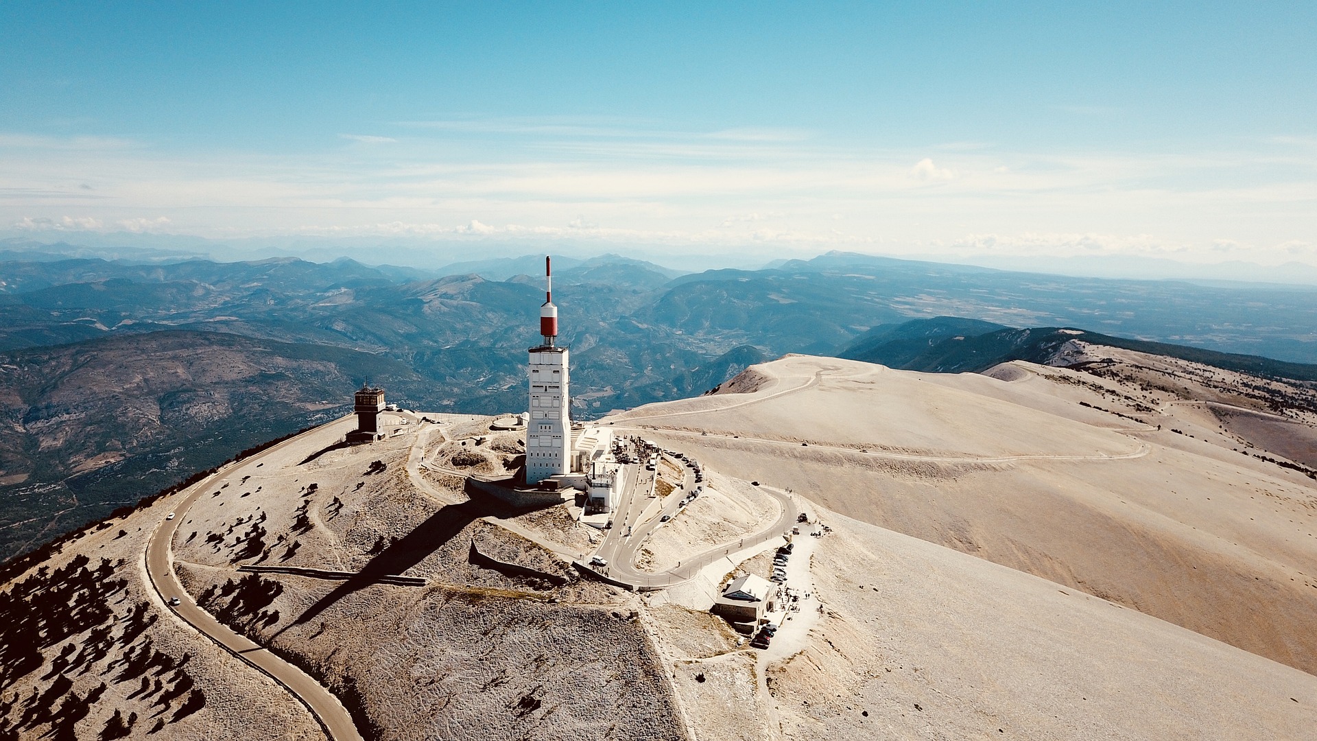
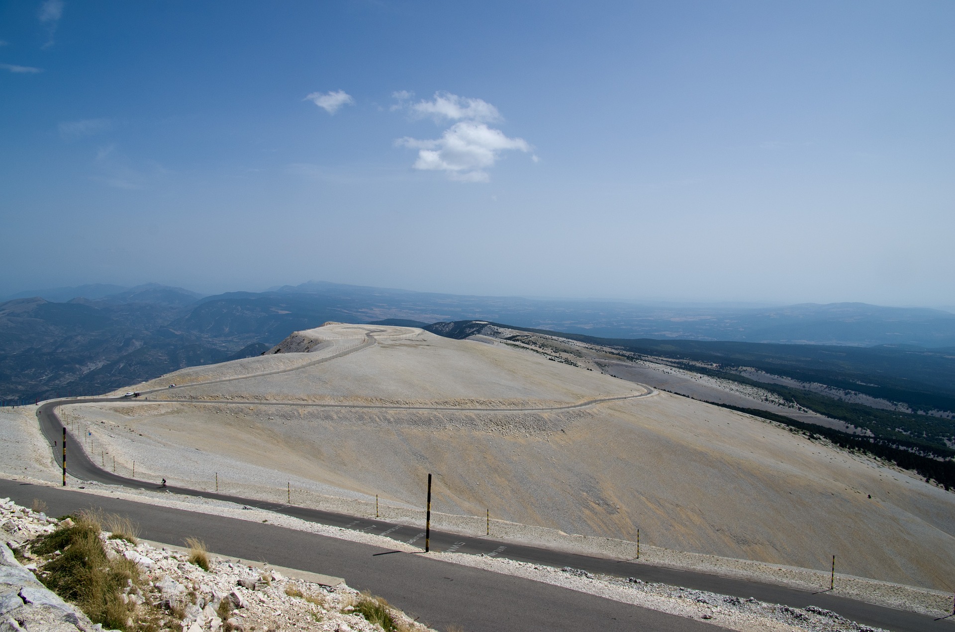
The Lunar Surface (Kilometres 15-21.5)
Mont Ventoux reveals its true nature above treeline: a mineral desert swept by violent winds entirely exposed to weather's full force. Mistral gusts regularly reach 100 km/h, with a recorded peak of 320 km/h—genuinely dangerous speeds that occasionally force complete road closure.
The white limestone scree covering the upper slopes creates an otherworldly landscape resembling lunar surface so strikingly that NASA and ESA regularly use the summit to test space equipment. The resemblance to moon terrain proves uncanny.
Wind becomes the primary adversary in these final kilometres. Crosswinds push riders across the road, headwinds reduce forward progress to crawling pace, and sudden gusts can literally stop riders completely. The psychological impact of this exposure after the forest's protection proves devastating to unprepared cyclists.
Temperature drops dramatically in this final section. A 15-20°C difference between Bédoin village and summit isn't unusual—arriving at the top hypothermic and exhausted represents a genuine risk without proper clothing.
Before your ascent, absolutely check real-time weather conditions via the Mont Ventoux website or local sources. The summit weather can differ dramatically from valley conditions. Wind speeds above 100 km/h close the road completely for safety.
Strategies to Tame the Giant
Physical and Mental Preparation
Mont Ventoux cannot be improvised by recreational cyclists. The Bédoin ascent demands specific preparation: solid endurance base, substantial hill work, acclimatization to prolonged effort at consistent intensity. Count on minimum 2 hours 30 minutes for experienced club cyclists, up to 4 hours for determined amateurs tackling their first ascent.
Mental factors count equally to physical capacity. The forest section wears you down psychologically through its viewless monotony, whilst the final exposed kilometres break bodies unprepared for the combination of gradient, wind, and accumulated fatigue.
Training should include repeated hill intervals maintaining threshold power for 20-30 minutes, mimicking the sustained effort Mont Ventoux demands. Long endurance rides building time in the saddle prove equally important—four hours represents significant duration requiring specific training adaptation.
Learn effective training methods and long-distance fuelling strategies applicable to this demanding climb.
Essential Equipment and Gearing
Adapted gearing proves mandatory: 34x28 chainring-to-cassette minimum, with many experienced cyclists recommending 34x32 for additional security. The gradient never relents sufficiently to recover in bigger gears—save energy through appropriate gear ratios throughout.
Temperature management requires attention: Conditions vary from 20°C in Bédoin village to sometimes 5°C at the windswept summit. A windproof jacket proves essential equipment even in apparently good weather. Arm warmers and full-finger gloves advised for the descent, which can feel genuinely cold after sweating heavily during the climb.
Hydration proves crucial: Carry 2 large bottles (750ml each) minimum, with mandatory refilling at Chalet Reynard. Dehydration-induced failures occur frequently in the final exposed kilometres where heat, wind, and effort combine to deplete fluid reserves rapidly.
Nutrition timing matters: Consume carbohydrates regularly throughout the climb—every 20-30 minutes without fail. The sustained intensity depletes glycogen steadily. Waiting until hunger signals appear indicates already critical delay. Read our mountain cycling nutrition guide for comprehensive fuelling strategies.
Additional equipment recommendations: Sunglasses essential for bright limestone glare, sun cream for extended exposure, basic tools and spare tube (limited mechanical support on mountain), and mobile phone with emergency numbers saved.
What You Won't Find Anywhere Else
Unique Microclimate and Geology
Mont Ventoux possesses a unique microclimate unmatched anywhere else in Europe. The weather station at the summit, operational since 1882, records temperature differences reaching 30°C between base and summit—extraordinary variation over just 21.5 kilometres horizontal distance.
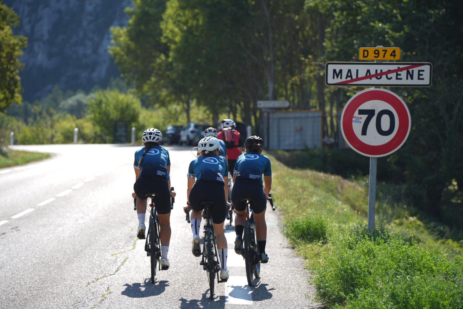
The south face via Bédoin stays consistently drier and warmer than the north face via Malaucène, creating entirely different ascent conditions depending on chosen route. This meteorological peculiarity results from the mountain's isolated position rising abruptly from surrounding plains.
The mountain's particular geology explains its distinctive lunar appearance. White Jurassic limestone, continuously eroded by 160 million years of relentless wind and weather, creates the barren upper slopes devoid of vegetation. The rock's brightness intensifies sunlight reflection, increasing heat stress on ascending cyclists.
The Club des Cinglés du Mont Ventoux
The Club des Cinglés du Mont Ventoux (Club of Mont Ventoux Crazies) gathers cyclists who conquered all three faces in a single day—a formidable challenge respected throughout the cycling community. Over 13,000 members since the club's creation, including approximately 2,000 British riders, testify to the challenge's international appeal.
The triple ascent totals 100 kilometres horizontal distance and 4,400 metres cumulative elevation gain—a genuinely exhausting day requiring exceptional fitness and mental determination. Paid participation costs €30 for the official recognition and right to suffer magnificently three times in one day.
Successful completion earns a certificate and the right to wear the distinctive club jersey—a badge of honour recognized by cyclists worldwide. Many riders describe completing the Cinglés challenge as their proudest cycling achievement, surpassing even multi-day tours or sportive events.
Frequently Asked Questions
What's the real difficulty of Mont Ventoux from Bédoin?
The 21.5km ascent with 1,600m elevation gain represents a major challenge for recreational cyclists. The 7.5% average gradient, including 15% passages through the forest, proves harder than most Alpine cols due to gradient consistency and wind exposure. Count on 2h30-4h depending on fitness level. Not recommended as a first significant climb—build experience on smaller ascents first.
What gearing should I choose for Mont Ventoux?
Minimum recommended gearing: 34x28 chainring-to-cassette ratio, with 34x32 ideal for less experienced climbers or those preferring additional security. The gradient never relents sufficiently to recover in bigger gears—appropriate gearing proves crucial for completing the ascent without complete exhaustion. Don't let pride compromise your climb with inadequate gearing.
When should I start to avoid summit wind?
Very early departure strongly advised—6-7am start from Bédoin village. Winds generally prove calmer in morning hours before heating triggers strong thermal winds. Early start also avoids intense heat in the forest section. Absolutely check real-time weather conditions before attempting: the road closes completely when winds exceed 100 km/h for safety reasons.
What equipment must I bring for the ascent?
Windproof jacket mandatory (even in summer), full-finger gloves for descent, 2 large water bottles minimum (750ml each). Expect 15-20°C temperature difference between Bédoin and exposed summit. Refuelling possible at Chalet Reynard (km 15)—use this opportunity. Sun cream, sunglasses, and basic tools complete essential kit. A gilet provides additional warmth insurance for summit and descent.
Is Mont Ventoux harder from Bédoin than Sault or Malaucène?
Yes, Bédoin represents objectively the most difficult ascent route. Sault (26km at 4.6% average gradient) remains significantly more accessible—a good introduction to Mont Ventoux for less experienced riders. Malaucène (21km, similar gradient profile) equals Bédoin in climbing difficulty but offers slightly less wind exposure in the final kilometres, making it marginally easier overall.
Can beginners attempt Mont Ventoux from Bédoin?
Possible but not recommended for genuine beginners. This ascent demands solid cycling fitness, previous climbing experience, and mental preparation for 2.5-4 hours sustained effort. Better to build experience on smaller climbs first. Our cycling holidays can introduce Ventoux progressively with professional guidance and support.
The Provençal Giant's Call
Mont Ventoux from Bédoin transcends simple sporting challenge. This ascent forges character as profoundly as it reveals physical limits. Between the forest's claustrophobic enclosure and the final section's total exposure to the elements, each cyclist experiences something uniquely personal and memorable.
The Tom Simpson memorial, located approximately one kilometre from the summit, reminds every passing rider that this mountain has witnessed everything—triumph, tragedy, heroism, and suffering in equal measure. Water bottles and small objects left by cyclists testify to universal respect for this history-laden place.
Simpson's last words—"Put me back on my bike"—spoken to spectators who caught him as he collapsed, epitomize the mountain's ability to push riders beyond rational limits. His memorial serves as both tribute and warning: respect Mont Ventoux or face consequences.
Completing Mont Ventoux from Bédoin joins you to cycling history. You follow wheel tracks of Simpson, Merckx, Pantani, Armstrong, Froome, and countless other legends who've suffered up these slopes. The summit represents more than geographical high point—it's entry into an exclusive club of cyclists who've conquered one of the sport's ultimate challenges.
Ready to experience this legendary ascent?
Explore our custom cycling trips designed around Mont Ventoux and other mythical Provence climbs. We provide expert guidance, professional support, and strategic planning that transforms this formidable challenge into an achievable, memorable experience.
Our road cycling holidays in Provence include proper preparation climbs building fitness and confidence before tackling Ventoux. With vehicle support, mechanical assistance, and experienced guides who know every metre of the ascent, we help you succeed where many fail.
Whether you're targeting Ventoux as a standalone objective or as part of a broader Provence cycling adventure, Baroudeur Cycling provides the expertise and support ensuring your Giant of Provence experience becomes a cherished memory rather than a regretful ordeal.
The mythical ascent awaits. Your cycling legend begins here.